

Finding green lanes for wet weather riding is mostly a question of what is under your wheels. A lane that is a joy in July can be a bog in November, while a gravel drove a few miles away barely changes all year. We went through every lane open to motorcycles* on Holloway, 8,106 km across England and Wales, to find the ones with a firm recorded surface that are worth riding when it has been raining for a week.
Why surface matters more than anything else in the wet
Clay holds water and turns to grease that clogs tyres within a few metres. Chalk goes glassy, especially on cambers and in ruts. Grass over soil looks harmless and offers almost no grip once it is wet, and churned earth gets deeper with every vehicle that passes. Gravel, hardcore and compacted stone drain freely, so the surface stays roughly where it was. That is the whole idea behind this list. If you want the longer version, our guide to riding chalk, clay and sand covers how each one behaves.
What the data says about green lane surfaces
Surface is one of the fields mappers record in OpenStreetMap, which is where much of our lane data starts. Of the 8,106 km of open lanes, 4,434 km have no surface recorded at all. Of the roughly 3,672 km that do, only about 879 km, around 24%, is gravel, compacted or other hard track. A further 388 km is sealed tarmac, asphalt or concrete. The rest is recorded as unsurfaced, unpaved, dirt, earth, ground or grass, which are the surfaces that suffer most in winter.
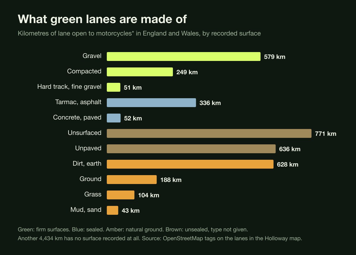
Recorded surfaces on open green lanes in England and Wales, by km. Firm surfaces are highlighted.
Firm lanes also cluster in particular places. Counting lanes of at least 1 km that are mostly gravel or compacted, Derbyshire has 16, Essex 12, North Yorkshire 11, Nottinghamshire 10 and Wiltshire 9. Wales has only one, but that says more about how sparsely Welsh surfaces are recorded than about the lanes themselves.
14 green lanes with firm surfaces for wet weather
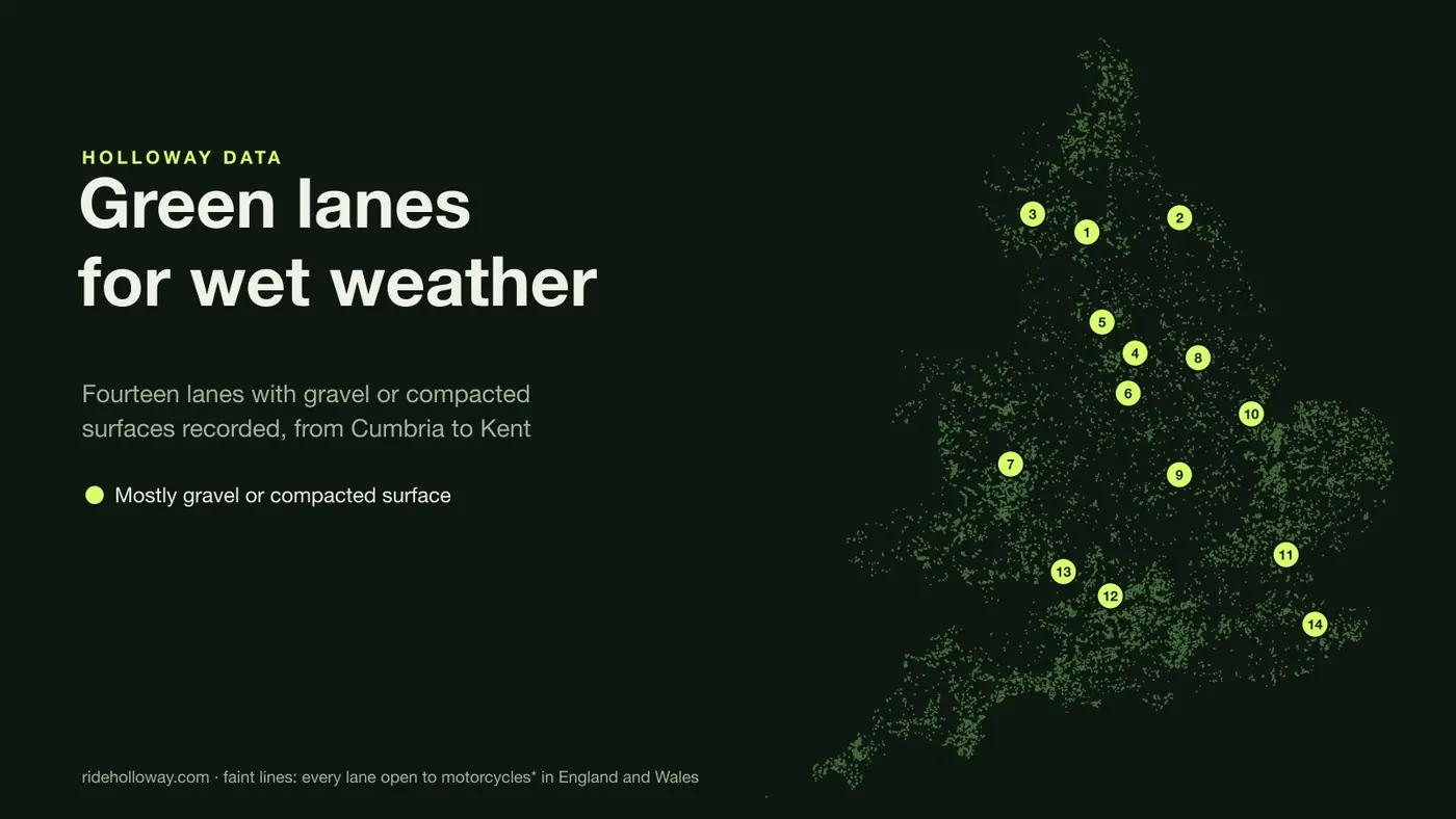
These are spread across England so most riders have one within reach. The numbers match the map above. Surfaces are as recorded by mappers, so treat them as a strong hint rather than a promise.
| # | Lane | km | Recorded surface |
|---|---|---|---|
| 1 | Cam High Road North Yorkshire | 10.2 | Gravel, with a tarmac section |
| 2 | Daleside Road North Yorkshire | 4.2 | Gravel |
| 3 | Dubbs Road Cumbria | 2.7 | Compacted |
| 4 | Houndkirk Road South Yorkshire | 3.8 | Compacted |
| 5 | Harrop Edge Lane Greater Manchester | 2 | Mostly compacted |
| 6 | Ridge Lane Derbyshire | 2.2 | Gravel |
| 7 | Kerry Ridgeway Shropshire | 3.6 | Gravel |
| 8 | Torksey Ferry Road Nottinghamshire | 2.7 | Compacted |
| 9 | Carvells Lane Northamptonshire | 2.5 | Gravel |
| 10 | Sea Bank Lincolnshire | 6.1 | Mostly compacted and gravel |
| 11 | The Essex Way Essex | 5.5 | Compacted and gravel, with some dirt |
| 12 | Yatesbury Lane Wiltshire | 3.7 | Mostly gravel |
| 13 | Woodend Lane Gloucestershire | 2.8 | Gravel |
| 14 | Pilgrim’s Way Kent | 1.3 | Compacted |
A few worth singling out
Cam High Road near Hawes is the longest on the list and one of the best known lanes in the country, a straight line over the fells that follows the Roman road west from Bainbridge. Most of it is recorded as gravel. It is exposed, so wind and low cloud are the bigger winter worry than mud. Our North Yorkshire trail riding guide covers the lanes around it.
Houndkirk Road on the edge of Sheffield and Harrop Edge Lane above Diggle are firm moorland tracks within easy reach of big towns. Moorland lanes can carry standing water and loose stone after heavy rain even where the base is solid.
Sea Bank at Fosdyke and Torksey Ferry Road on the Trent are flat, firm and a good choice when the hills are miserable. Flood banks are open to the weather, and low-lying lanes near rivers can flood outright, so check before you go.
Yatesbury Lane in Wiltshire is a gravel option in chalk country, where many neighbouring lanes turn slick in the wet. See the Wiltshire guide for more.
Riding firm lanes in the wet
- Gravel is not grip. Wet stone over a hard base still slides, especially on descents and off-camber corners. Stay off the front brake on loose stuff and let the bike move around a little.
- Drop tyre pressures a few psi from road settings if your tyres and rims allow it. Our guide to the best tyres for green laning by season covers what works in winter.
- Puddles on firm lanes often hide potholes. If you cannot see the bottom, ride round it or go through slowly in a straight line. The same rules as our water crossing guide apply.
- Kit and bike prep matter more than usual. Our wet season prep guide has the checklist.
- If a lane is badly cut up, turn round. Riding a soft lane in winter is how lanes end up closed, and once a closure order is in place it rarely comes off.
Check before you ride
Recorded surfaces are only as good as the last person who mapped them, and conditions change with every storm. Some councils also close lanes over winter. Open any lane in the Holloway map before you set off to see its current legal status and any closures or cautions we hold, and check the signs at each end.
How we picked these lanes
We started from every lane recorded as a byway open to all traffic or unclassified road with no closure, seasonal order, caution or unverified note in our data, excluding Ireland. We kept lanes of at least 1 km where most of the length is recorded as gravel, compacted or similar firm surfaces, then chose a spread across England. We left out anything tidal, such as crossings on Morecambe Bay sands. Surface figures come from OpenStreetMap tags as held in our data on 10 November 2026.
*Open to motorcycles means the lane is recorded as a byway open to all traffic or an unclassified road, with no closure or caution on it in our data at the time of writing. Legal status changes and our data is for reference only, so check the signs and any current traffic regulation orders before you ride. How we check lanes.