

You're two lanes into a day out. The last one wasn't on the plan, someone suggested it at the layby, it looked worth a go. Now there's a fork ahead, the phone's showing one bar flickering to none, and the map that worked fine at breakfast has stopped loading. You're guessing.
Every green laner has had some version of this. It's not bad luck. It's what happens when a map is built around an assumption that doesn't hold in the places you actually ride.
This is a design failure, not a user failure
Green lanes exist in the gaps. The Ridgeway crosses stretches of the Chilterns where signal comes and goes. The Elan Valley in mid Wales has whole valleys with nothing. The North York Moors, the higher reaches of Exmoor, plenty of Bedfordshire's quieter lanes too, they all sit in spots mobile networks were never built to reach, because nobody built a mast for a byway.
A map that needs a live connection to function was designed for towns and A-roads, then pointed at terrain it was never tested against. When it fails on a green lane, that's not you doing something wrong. That's the tool failing at the one moment you needed it most.
Caching a screenshot isn't the same as offline-first
Plenty of apps offer something they call offline mode, and most of it means one thing, a cached image of the area you were looking at before you lost signal. That's better than nothing, but it's static. You can't search it, you can't tap a lane for its legal status or hazards, and if the fork ahead sits just outside the bit of map you happened to have open, you're stuck.
Offline-first is a different approach entirely. It means the full dataset, the lanes, their legal type, their difficulty and hazards, is stored on the device from the start, not fetched on demand. Signal becomes something the app can use if it's there, not something it depends on to work at all.
How Holloway approaches it
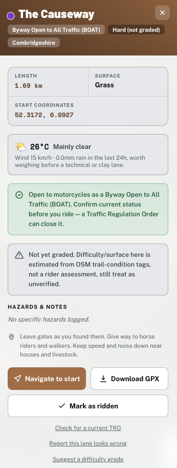
Holloway is built around the idea that a green lane app has to assume no signal after you've left the house as the default case, not the exception. Install the app and open it once with a connection, and after that the search, the filters and every lane's name, legal type, difficulty, length and hazard notes are there whether or not your phone can see a network, nationally, not just wherever you happened to be standing when you opened it. The one thing that still needs a connection first is the map's own visual background for an area you've genuinely never looked at before, so the honest habit is to glance over your planned area while you've still got signal, not assume the whole country loaded itself in the background. You're not looking at a static image either way, you're looking at a searchable, offline dataset that just needs one look at new scenery before it can draw it.
The old way of finding lanes, word of mouth, forum threads, shared GPX files, has the same weakness running through it: none of it was built with the reality of rural signal in mind. Fixing that properly means building for it from the ground up, not patching it on afterwards.
"A map that only works near a mast isn't a map for green laning, it's a map for somewhere else that happens to show your lane on it. We built Holloway assuming you'd have no signal, because on most rides that's exactly what happens."
— Mat Stuckey, founder of Holloway
What to do before your next ride
If you don't have an offline option sorted yet, a few things matter more than the rest before you head out:
- Download or cache the area you're riding before you leave a signal zone, not once you've already lost it.
- Check each lane's legal status and any closures in advance. A restricted byway, bridleway or footpath is never legal for motor vehicles, however open it looks on the ground, and that's not something you want to be working out at a junction with no signal to check.
- Carry a paper OS map as a genuine backup, not a formality. Batteries fail as often as signal does.
- If you're planning a full day linking several lanes, sort your route before you go rather than improvising junction by junction. Improvising is exactly where signal gaps cause the most trouble.
Legal status can change and signage on the ground always takes priority, so treat any map, offline or not, as reference information to check against what you actually find at the gate.
Get set up properly
Holloway's free to use: search, filters and every lane's legal type, difficulty, hazards and closure status, available offline everywhere in England and Wales once you've opened the app online. The map's own visual tiles need a connection the first time you view a new area, so give your planned route a look while you've still got signal. For £20 a year, Holloway Premium adds full route planning with road-following connectors between lanes, GPX export, exact coordinates, live weather and navigate-to-start, so you can build a full day out and carry the whole thing with you, signal or none at all.